© The Indian Express Pvt Ltd
Premium
Storm in Delhi, floods in hill states: Impact of climate change-induced changing patterns of Western Disturbances
Delhi and its surrounding areas woke up to heavy rainfall and strong winds on Friday. They brought relief amid the May heat, but what exactly triggered these unseasonal rains? Does climate change have a role to play?
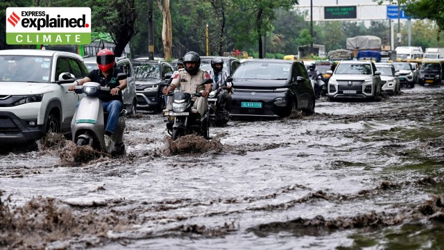 Commuters wade through a severely waterlogged road after rainfall near Vikas Marg, at ITO in New Delhi on Friday. (Photo: ANI)
Heavy rainfall and strong winds were witnessed across Delhi and its surrounding region on early Friday (May 2) morning, leading to waterlogging at several locations and flight disruption at the Indira Gandhi International Airport. The weather conditions were triggered by a fresh Western Disturbance over northern and northwestern parts of the country, according to the India Meteorological Department (IMD).
Notably, there has been an increase in the frequency of Western Disturbances this year which is directly linked to soaring global temperatures, according to a new analysis by Climate Trends, a Delhi-based climate research organisation. The analysis, which was published last week, also found that the change in behavioural pattern of the weather system resulted in heavy rainfall, flash floods, and landslides in Himalayan states such as Jammu & Kashmir, Himachal Pradesh and Uttarakhand in March and April. It also helped keep prolonged heatwaves at bay in northwestern plains.
“After remaining insignificant till January, Western Disturbances picked up frequency from late January onwards and have been affecting Western Himalayas at regular intervals. The influence of Western Disturbances has been growing significantly over Jammu and Kashmir, Himachal Pradesh and Uttarakhand. They have been dumping more rainfall over the Himalayan region, which is directly related to climate change,” Dr K J Ramesh, former director general of meteorology, IMD, told Climate Trends.
Here is a look at how climate change is affecting Western Disturbances.
But first, what are Western Disturbances?
Western Disturbances are east-moving rain-bearing wind systems that originate beyond Afghanistan and Iran, and pick up moisture from the Mediterranean Sea, Black Sea, Caspian Sea and the Arabian Sea.

These are examples of extra-tropical cyclones that are a result of low-pressure areas formed due to the interactions between polar and tropical winds. Western Disturbances are embedded within the subtropical westerly jet stream — a high-altitude, fast-moving air current that flows from west to east in the Earth’s atmosphere — that lies over the Himalayan and Tibetan highlands.
They are most common during the boreal winter months (December to March) and influence weather over India, particularly the northwestern regions, Pakistan, Afghanistan, and Tajikistan.
Story continues below this ad
How is climate change affecting Western Disturbances?
Experts believe that rising global temperatures are affecting the traditional behaviour of Western Disturbances. For instance, Western Disturbances that occur in winter have increased significantly over the western and central Himalayas and the Hindu Kush in the last 70 years, according to a 2024 study, published by the journal Weather and Climate Dynamics.
This could be happening due to the strengthening of the subtropical westerly jet stream, meaning the wind currents within the jet stream are becoming faster and stronger. Scientists suggest that warmer temperatures have a pivotal role in making such jet streams stronger.
Western Disturbances are also now impacting the weather outside the winter season. In the last 70 years, they have become more common in May, June, and July, months where they were previously rare, according to the 2024 study. One reason for this trend could be the “delayed northward retreat of the subtropical jet, which historically has occurred before the onset of the summer monsoon.”
As a result, there has been an increase in instances where Western Disturbances have occurred during monsoon, leading to a rise in extreme weather events such as heavy rainfall and floods.
Story continues below this ad
Changes in the characteristics of Western Disturbances could also be because of the year-round moisture feeding. One of the main reasons for this is the rapid warming of the Arabian Sea in recent decades, which has resulted in the release of more moisture. A 2022 study, published in the journal Earth Science Reviews, found that sea surface temperatures over the Arabian Sea increased by 1.2 degrees Celsius to 1.4 degrees Celsius in recent decades compared to four decades ago. This has likely made precipitation more frequent and intense.
Soaring temperatures have broadened the subtropical westerly jet stream, allowing Western Disturbances to travel in different directions in a wider area, according to the Climate Trends analysis.
“Western Disturbances will now have more meridional oscillations (leading to a change in temperature and precipitation), which means that they can now travel to the north boundary as well as to the south boundary of the jet. Earlier, there was not enough space for such oscillation in comparison to the present situation,” Dimri said.
Advertisement

More Explained


Top Stories


Advertisement
Must Read


Advertisement
Buzzing Now
TrendingDelhi University to introduce relationship course for GenZ on love and friendship, students to review films like ‘Kabir Singh’

TrendingAnand Mahindra hails Carlos Alcaraz’s historic French Open comeback: ‘Worth a thousand pep talks’

TrendingAmul butters up the Donald Trump-Elon Musk online spat with special topical; netizen reacts: ‘Ye company band karake manega’


EXPRESS OPINION


Jun 10: Latest News
- 01
- 02
- 03
- 04
- 05
Advertisement